-David

Showing posts with label New Zealand. Show all posts
Showing posts with label New Zealand. Show all posts
Thursday, March 22, 2012
Bungy video!
Finally, the video you have been waiting for! Watch me take the plunge at Kawarau Bridge in Queenstown, NZ.
-David
-David
Monday, January 23, 2012
New Zealand in a nutshell
 |
| Sheep in New Zealand |
A short (well, not really) New Zealand overview. Beyond just listing our top three favorite things, this is a compilation of things that we learned while traveling around NZ.
David’s Top Three:
Waitomo Caves
Routeburn Track and Milford Sound
Bungy!
Sara’s Top Three:
Rail Trail
Tongariro AlpineCrossing/Routeburn Track (tie!)
Arrowtown
Transportation
We rented a car for our entire 22 days (loved Apex car rentals) and drove more than 2,000 km. We figure that is at least 25 hours in the car, probably more. That gave us plenty of time to enjoy the beautiful scenery, read about NZ, play games, and write some blog posts. Gas is expensive - about $2.10 NZD per liter (about $6.35 per gallon), which meant about $75 to fill up the tank.
For us, having a car was absolutely the best way to see NZ! The driving is really easy (even on the left side). All we needed was a few road maps and we were set. There just aren't too many roads here, and there aren't too many cars either. Almost all of the roads outside of the big cities are two-lane, and many bridges are one-lane.
When planning our NZ leg, we really considered renting a campervan, which is really common here. It only took a day or so before we both agreed that a campervan would have gotten tiring really quickly for us.
Saturday, January 21, 2012
Christchurch
We are flying out of Christchurch airport tomorrow, so we are here for the night. I haven't known what to expect in Christchurch. - everything I heard seemed to talk about the city before the 2011 earthquake.
The city, especially the city center, has been completely devastated. We spent most of the afternoon walking around and it is so easy to see that Christchurch used to be an absolutely charming and bustling city. I can imagine that it would have been my favorite city in NZ - a tram system in the city center, the Avon River, and several huge parks. We weren't able to see much. The city center is fenced off as a red zone. But you can see the damage everywhere - buildings with scaffolding covering them, huge cranes, and crumbled buildings everywhere. We never really saw anyone working in the red zone and it was hard to tell if people were rebuilding or just demolishing. With so many aftershocks since the initial quake, it seems like people maybe can't decide what to do. As David said, it felt a bit like we were on a movie set.
There were a few good things that we saw. There is an organization called Re:Start that has built a pedestrian mall and shopping area in a corner of the old city center. The stores and restaurants were constructed from shipping containers painted in bright colors There were several signs on businesses saying "we are glad to be back," but there were just as many offering spiritual or counseling services for people who are grieving or asking for help and donations. We had a great lunch and dinner and enjoyed some live music, but I leave here feeling such sadness for the city and the people.
~Sara
The city, especially the city center, has been completely devastated. We spent most of the afternoon walking around and it is so easy to see that Christchurch used to be an absolutely charming and bustling city. I can imagine that it would have been my favorite city in NZ - a tram system in the city center, the Avon River, and several huge parks. We weren't able to see much. The city center is fenced off as a red zone. But you can see the damage everywhere - buildings with scaffolding covering them, huge cranes, and crumbled buildings everywhere. We never really saw anyone working in the red zone and it was hard to tell if people were rebuilding or just demolishing. With so many aftershocks since the initial quake, it seems like people maybe can't decide what to do. As David said, it felt a bit like we were on a movie set.
There were a few good things that we saw. There is an organization called Re:Start that has built a pedestrian mall and shopping area in a corner of the old city center. The stores and restaurants were constructed from shipping containers painted in bright colors There were several signs on businesses saying "we are glad to be back," but there were just as many offering spiritual or counseling services for people who are grieving or asking for help and donations. We had a great lunch and dinner and enjoyed some live music, but I leave here feeling such sadness for the city and the people.
~Sara
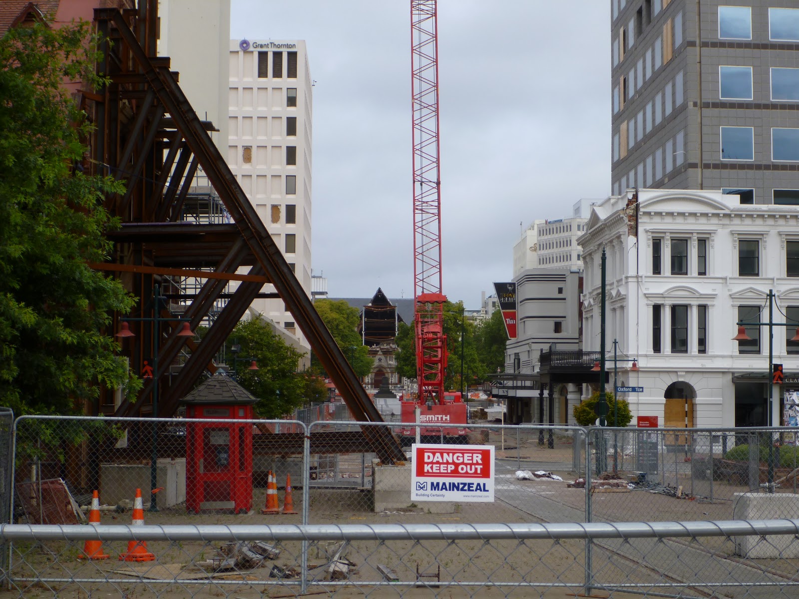 |
| A section of the red zone - the old Christchurch Cathedral can be seen in the background |
Friday, January 20, 2012
Tired
We are
tired!
We decided
to do an easy three hour hike at Mt. Cook (NZ’s highest peak) along the Hooker
Valley Track. The morning of the hike we
woke up to a forecast of 90 km per hour winds but really didn’t think too much
of it. We should have! Instead of the easy three hour hike we
expected, we ended up fighting our way through a virtual wind tunnel. The gusts were hard to stand up against – we were
just thankful that we were in a valley and not dealing with those winds on top
of the mountain. We ducked behind a huge
boulder for lunch – I thought it went well until I stood up and realized that
my rain jacket (yes, it was drizzling too) was covered in jelly. Oh excellent! It was around that time that I realized that
mountains covered in glaciers aren’t the most hospitable places on earth.
Needless
to say, we finished the hike and both immediately agreed that we wanted to do
absolutely nothing for the rest of the day!
~Sara
Rail Trail
 |
| The Otago Central Rail Trail |
I think
this was my favorite thing we have done in New Zealand, really! It was a bit of a dream come true, because I
have always wanted to do an overnight bike trip. It was even better than I had imagined. The landscape was incredible (I felt like I
was riding through a painting). To top
it off, we had a wonderful dinner at the only restaurant in Oturehua and
the most relaxing stay at a great B&B that used to be the old shop for the
general store in town.
The Otago
Central railroad was 150 km of rail linking Clyde to Dunedin and all of the
small gold mining towns in between. The
railroad shut down in the 1990s, but instead of going to waste, someone had a
brilliant idea to rip up the rail and create the Rail Trail for
bikers, walkers and horseback riders.
Now these towns cater to bike riders rather than gold miners. We rode 84 km of the trail from Omakau to Oturehua (where we stayed the
night), then on to the highest point on the trail on day two before heading back
to Omakau. We met a lot of New
Zealanders who were riding from one end to the other in about five days, but
after two days of riding on gravel our bodies were pretty tired.
~Sara
No Shoes, No Problem!
Restaurants,
grocery stores, hiking trails . . . in New Zealand it seems that shoes are
always optional!
 |
| A supermarket in New Zealand - no shoes, no problem! |
Thursday, January 19, 2012
5-4-3-2-1 Bungy!
I did it!
Sara and I visited the world’s very first bungy site at Kawarau Bridge
outside of Queenstown. After watching a
few jumps (and against my better judgment), I decided to take the plunge. Before I knew it, I had swiped the credit
card (nonrefundable) and stepped on the scale.
Then came the long walk out to the middle of the bridge.
Needless to say I was pretty nervous, so my memory is a little fuzzy. I asked several of the folks working on the ledge how many jumps they had done. None would admit ever jumping. They said I was crazy, and I agreed. One girl asked me whether I wanted to touch the water below the bridge, and I said okay, but definitely no more than my fingertips.
The butterflies really started in earnest as I shuffled out to the ledge. I paused just long enough to give Sara a thumbs up, and then I jumped. Perhaps I actually weigh more than 86 kilos, because I was dunked up to my shoulders in the river below the bridge! I was very relieved to bounce back up into the air. I did get a little rope burn on my ankle, but otherwise came through in one piece.
Check bungy jumping off the bucket list . . . I don’t think I will be doing anything so crazy again anytime soon!
-David
Needless to say I was pretty nervous, so my memory is a little fuzzy. I asked several of the folks working on the ledge how many jumps they had done. None would admit ever jumping. They said I was crazy, and I agreed. One girl asked me whether I wanted to touch the water below the bridge, and I said okay, but definitely no more than my fingertips.
The butterflies really started in earnest as I shuffled out to the ledge. I paused just long enough to give Sara a thumbs up, and then I jumped. Perhaps I actually weigh more than 86 kilos, because I was dunked up to my shoulders in the river below the bridge! I was very relieved to bounce back up into the air. I did get a little rope burn on my ankle, but otherwise came through in one piece.
Check bungy jumping off the bucket list . . . I don’t think I will be doing anything so crazy again anytime soon!
-David
 |
| David at Kawarau Bridge Bungy |
 |
| David at Kawarau Bridge Bungy |
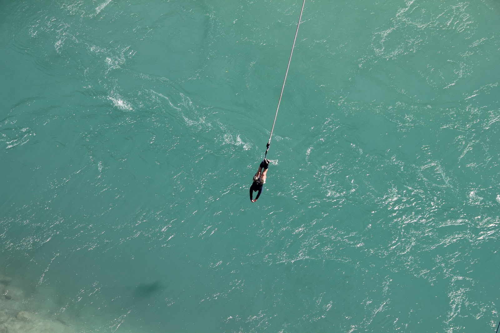 |
| David at Kawarau Bridge Bungy |
Milford Sound
Milford Sound is a craggy fiord that must top any list of the most beautiful places on earth. Cliffs rise thousands of feet directly from the sea, and dozens of waterfalls pour down the cliffs from the snow-covered peaks above. The pictures hardly do it justice.
Milford is only about a 30 minute drive from the end of the Routeburn Track (the road itself is a feat of engineering). For a place where it rains 50+ feet per year, we were fortunate to have a rare blue sky day for a cruise through the fiord. Sara loved seeing a group of seals that call Milford home. It was one of the prettiest places that I have ever seen.
On the ride back to Queenstown we reached over 45 degrees South latitude -- the southernmost place that either of us has ever visited!
Milford is only about a 30 minute drive from the end of the Routeburn Track (the road itself is a feat of engineering). For a place where it rains 50+ feet per year, we were fortunate to have a rare blue sky day for a cruise through the fiord. Sara loved seeing a group of seals that call Milford home. It was one of the prettiest places that I have ever seen.
On the ride back to Queenstown we reached over 45 degrees South latitude -- the southernmost place that either of us has ever visited!
 |
| Milford Sound |
 |
| Seals in Milford Sound |
 |
| Milford Sound |
-David
Arrowtown and Queenstown
Before and after the Routeburn Track, we spent several nights in Arrowtown and Queenstown. Arrowtown is a quaint old mining town not far outside of Queenstown. It was our favorite of the two without a doubt! After dinner (and ice cream, of course) we wandered around the town. And speaking of ice cream, Hokey Pokey (vanilla with honeycomb) is the most popular flavor in NZ and a new favorite for Sara!!
The best things happen when you just wander around, which is just what we were doing after dinner and ice cream. Next thing you know we found ourselves in a lawn bowling club making friends with a lively group of locals. In between their Speights (the local beer on the South Island), the group gathered together some equipment and taught us the rules. After a few ends, we clearly needed help. In walked Tom. Tom is an Arrowtown local, who took it upon himself to coach us on the proper bowling technique. We were very confused when Tom kept telling us to "just keep the wee bit to the inside." We finally realized that Tom meant that we should keep the smaller picture on the weighted balls to the left as we bowled. All in all, we had a great time learning. Visitors are invited into almost all of the bowling clubs in New Zealand and Australia, so we are hoping to find more clubs over the next few weeks and to improve our games!
Queenstown lived up to its title as the adventure capital of New Zealand. There was so much going on. Around every corner there was an amazing and easy way to spend $300+ on an adrenaline-pumping activity. While it wasn't our favorite town, it was very picturesque and a perfect jumping off point for the Routeburn Track and other activities!
 |
| Main Street in Arrowtown |
 |
| An old church in Arrowtown |
The best things happen when you just wander around, which is just what we were doing after dinner and ice cream. Next thing you know we found ourselves in a lawn bowling club making friends with a lively group of locals. In between their Speights (the local beer on the South Island), the group gathered together some equipment and taught us the rules. After a few ends, we clearly needed help. In walked Tom. Tom is an Arrowtown local, who took it upon himself to coach us on the proper bowling technique. We were very confused when Tom kept telling us to "just keep the wee bit to the inside." We finally realized that Tom meant that we should keep the smaller picture on the weighted balls to the left as we bowled. All in all, we had a great time learning. Visitors are invited into almost all of the bowling clubs in New Zealand and Australia, so we are hoping to find more clubs over the next few weeks and to improve our games!
 |
| David getting instruction on scoring from Tom |
 |
| Sara practcing her new lawn bowling technique action with Tom watching on |
Queenstown lived up to its title as the adventure capital of New Zealand. There was so much going on. Around every corner there was an amazing and easy way to spend $300+ on an adrenaline-pumping activity. While it wasn't our favorite town, it was very picturesque and a perfect jumping off point for the Routeburn Track and other activities!
Wednesday, January 18, 2012
Another Great Walk
 |
| Snow on Day Two of the Routeburn Track |
 |
| At the Key Summit on Day Three of the Routeburn Track |
Rain on day one, snow on day two, and perfect blue skies on day three. What a hike! Despite being a bit wet and cold, we loved the Routeburn Track! The track was about 35 km total with quite steep climbs and descents.
We started the hike pretty early on the first day, so once we made it to our first hut at Routeburn Falls, we immediately chose our bunks and laid out our sleeping bags (which we were so thankful to have). We then stayed near the coal stove in the main common room of the hut to dry out from the rainy day. This time we heard the huts had gas burners, so we got a bit smarter and brought a can of garbanzo beans that we heated up for dinner. Excellent! There were some great people in the hut, so we had fun chatting and playing card games. The only thing missing was s'mores. New Zealanders have never even heard of s'mores!
We stayed plenty warm overnight, but woke up to several people in the bunk room saying "it's snowing!" We definitely didn't bargain for that (after all, it's summer down here!). We did the best we could by layering up with all of the clothes that we brought, topped off with our waterproof gear. Unfortunately, our gloves weren't waterproof, so that is one change that we would have made. The track on the second day was above the tree line, so the trail was exposed for the entire 11.3 km. About three inches of snow fell while we were hiking, and someone even built a pretty good snowman alongside the trail. This was definitely our toughest day of hiking, but 4 hours and 45 minutes later we made it to the Lake Mackenzie Hut. After another round of drying everything off, we spent the evening around the fire.
We woke up to a perfect blue sky and crisp temperatures on our final day. Such a treat after the first two days! This also meant that we would get to see some nice views, which we had missed on the first two legs. The last leg was really fun, and we even took a side trail up to a summit for amazing 360 degree views of the New Zealand fiordland.
Despite the conditions, we both really loved the hike (it was David's favorite so far). Another Great Walk!
 |
| A collage of our hike on the Routeburn Track |
From left to right:
Picture 1: A swinging bridge at the start of day one - before the rain.
Picture 2: A nice view of the river on day one - before the rain.
Picture 3: The common room at Routeburn Falls Hut.
Picture 4: The deck at Routeburn Falls Hut.
Picture 5: The Routeburn Falls, which gave our first hut its name.
Picture 6: David in the snow at the start of day two.
Picture 7: Lake Harris, not as pretty as on a sunny day.
Picture 8: Lake Mackenzie - the snow finally stopped after dinner on day two.
Picture 9: A view back over the range that we crossed.
Fox Glacier
 |
| Fox Glacier |
 |
| Fox Glacier |
On our second day down the West Coast the weather turned. We had planned to visit the Franz Josef Glacier, but it was very rainy in the car park at the trail head. We decided to keep driving south toward the Fox Glacier instead. The rain had eased by the time we arrived to Fox Glacier. It was a one hour walk to and from the glacier so we figured that we would make our way as quickly as possible before the rain returned. We made it to the glacier without a hitch, and it was really cool to be so close to the glacier! But about a minute after turning back toward the car, the bottom fell out. We had on rain coats, but every other part of us was dripping wet when we arrived back to the car. We both agreed that it was worth it, but it sure was an interesting start to another six hours in the car.
Friday, January 13, 2012
Back into the wilderness
We leave early tomorrow morning for our next hiking adventure - three days on the Routeburn Track outside of Queenstown in Fiordland National Park. The forecast calls for much colder weather than we had at Abel Tasman. The huts we sleep in have wood stoves but no electricity, so today we picked up a couple sleeping bags at the Warehouse (NZ's Walmart). The forecast is also calling for rain so here's hoping we stay warm and dry (the waterproof gear should help)!
Back in a few days . . .
Back in a few days . . .
Thursday, January 12, 2012
The West Coast
 |
| A picture from the first lookout point on the West coast of New Zealand |
The West Coast of NZ is breathtaking! We were lucky enough to get a blue sky cloudless day and so around every turn we felt the need to stop for more pictures. The drive along the coastline is a couple hundred kilometers. After the first few stops we realized it would take us a bit too long if we actually did stop at every lookout!
We made one stop at Punakaiki to see the "pancake rocks." Although a bit touristy, they were really amazing to see! You can tell from the picture below that the layered rocks have eroded to look a bit like pancakes, giving them their name. There was also a really neat blowhole that was pretty active at high tide when we were there.
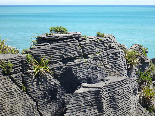 |
| Punakaiki Rocks |
 |
| Punakaiki Rocks |
Guess Who Drove Today?
 |
| Sara driving the Nissan Sunny that we rented in New Zealand |
I drove us most of the way down the West Coast of the South Island and it went quite well -- David was also really glad to have a break from driving! It seems funny, but being comfortable driving on the left side feels like a real accomplishment to me.
~Sara
Wednesday, January 11, 2012
A Great Walk
We’re back from the Abel Tasman Coast Track, one of New Zealand’s nine “Great Walks.” Although we expected rain each day it turned out to be beautiful weather. Only a bit of rain after we arrived to our hut on the first night and a little bit more as we walked back to our car in Marahau – crossing our fingers worked!! The hike had some really stunning views and very interesting terrain with dense forest, coastline and beaches, as well as several estuaries that could only be crossed within a couple of hours of low tide. We hiked just over 42 km total, so it was pretty tiring too!
Day 1 was a nice, gentle hike of about 12 km beginning in Marahau, where we left our car. The trail began with a boardwalk across a large estuary at the southern end of the national park. It continued along the coastline and up through a dense tropical forest. Near the end of the day we passed through a very dry section – almost like an arroyo in New Mexico or Arizona. Finally we arrived to our first hut, Anchorage, on a pretty little cove at about 4:30 p.m. Lunch and dinner were trail mix and peanut butter sandwiches (you may start to see a pattern).
Day 2 was our longest and hardest day. We hiked a hilly 25 km from Anchorage hut to Awaroa hut. We tried to maintain a pretty steady pace throughout the day because we had to arrive to Awaroa within three hours of low tide, which was at 4:30 p.m. We also knew that there was a pizzeria associated with a fancy lodge (complete with airstrip) about 30 minutes from our hut. We were very motivated by the idea of something other than peanut butter sandwiches, which had been lunch again that day. The hike was really tough, but the pizza and Cokes at the end, as well as a really neat hut on a big estuary, made it all worthwhile.
Day 3 was a very early morning. We were up at 6:00 a.m. in order to cross the final estuary before high tide rolled in. Even at low tide we had to cross in our bare feet because the water came up to our mid-calves in a lot of places. We hiked about 6 km and ended at the Totaranui camp grounds where we waited for a water taxi to shuttle us back to our car.
The water taxi ride was awesome! About 40 minutes into the ride back to Marahau, we came across a pod of pilot whales. We think we saw about 30 whales, and we were within 50 feet at one point. It was just amazing! Even our water taxi driver was impressed; it was the first time he had seen pilot whales in 30+ years at Abel Tasman.
Now that we are showered and relaxed we can say that it was a really wonderful hike and experience! And as an added bonus we got to check whale-watching off of our list :)
From top left
Picture 1: A view from the trail on the first day.
Picture 2: David at Cleopatra’s Pool.
Picture 3: On a suspension bridge crossing a river on Day Two.
Picture 4: Awaroa Hut.
Picture 5: Pizza dinner at Awaroa Cafe.
Picture 6: Sara crossing the estuary.
Picture 7: Totaranui beach in the morning sun.
Picture 8: We’re finished!
Picture 9: Whale-watching from the water taxi.
Day 1 was a nice, gentle hike of about 12 km beginning in Marahau, where we left our car. The trail began with a boardwalk across a large estuary at the southern end of the national park. It continued along the coastline and up through a dense tropical forest. Near the end of the day we passed through a very dry section – almost like an arroyo in New Mexico or Arizona. Finally we arrived to our first hut, Anchorage, on a pretty little cove at about 4:30 p.m. Lunch and dinner were trail mix and peanut butter sandwiches (you may start to see a pattern).
Day 2 was our longest and hardest day. We hiked a hilly 25 km from Anchorage hut to Awaroa hut. We tried to maintain a pretty steady pace throughout the day because we had to arrive to Awaroa within three hours of low tide, which was at 4:30 p.m. We also knew that there was a pizzeria associated with a fancy lodge (complete with airstrip) about 30 minutes from our hut. We were very motivated by the idea of something other than peanut butter sandwiches, which had been lunch again that day. The hike was really tough, but the pizza and Cokes at the end, as well as a really neat hut on a big estuary, made it all worthwhile.
Day 3 was a very early morning. We were up at 6:00 a.m. in order to cross the final estuary before high tide rolled in. Even at low tide we had to cross in our bare feet because the water came up to our mid-calves in a lot of places. We hiked about 6 km and ended at the Totaranui camp grounds where we waited for a water taxi to shuttle us back to our car.
The water taxi ride was awesome! About 40 minutes into the ride back to Marahau, we came across a pod of pilot whales. We think we saw about 30 whales, and we were within 50 feet at one point. It was just amazing! Even our water taxi driver was impressed; it was the first time he had seen pilot whales in 30+ years at Abel Tasman.
Now that we are showered and relaxed we can say that it was a really wonderful hike and experience! And as an added bonus we got to check whale-watching off of our list :)
 |
| A collage of our trip on the Abel Tasman Coastal Track |
From top left
Picture 1: A view from the trail on the first day.
Picture 2: David at Cleopatra’s Pool.
Picture 3: On a suspension bridge crossing a river on Day Two.
Picture 4: Awaroa Hut.
Picture 5: Pizza dinner at Awaroa Cafe.
Picture 6: Sara crossing the estuary.
Picture 7: Totaranui beach in the morning sun.
Picture 8: We’re finished!
Picture 9: Whale-watching from the water taxi.
Saturday, January 7, 2012
Abel Tasman Coast Track
We are off for three days of hiking on the Abel Tasman Coast Track - fingers crossed for good weather!
Marlborough Wine Region
 |
| At Cloudy Bay Winery |
Exploring the Marlborough wine region was such a treat! We stopped at four wineries: Lawson's Dry Hills, Wither Hills, Cloudy Bay, and Hans Herzog. Our favorite wines were a few of the Sauvignon Blancs and Gewurztraminers. Each winery had its own unique flavor and atmosphere, but we both quickly chose Cloudy Bay as one of our favorites. Not only was the wine fantastic, but we sat in the swings outdoors for about 30 minutes just enjoying the scenery.
 |
| David relaxing on the swings at Cloudy Bay |
Leaving the wine region we headed to Nelson for the night. After a recommendation from a gas station attendant, we stopped to eat at Haven's Fish & Chips - wow! After confirming that the raw fish and mussels on display could be cooked and eaten in the picnic area, we enjoyed an awesome dinner. Possibly our favorite so far!
 |
| Dinner at Haven's Fish & Chips in Nelson |
Windy Welly
This morning we left Wellington for the South Island. We had a great few days exploring "Windy Welly" as it is called by the locals!
We arrived in Wellington on Thursday and luck had it that the Te Papa museum, New Zealand's national museum, stays open late on Thursday nights. After a fantastic Malaysian dinner on Cuba Street, we headed toward the museum. We learned a lot about NZ and the native Maori culture. One interesting bit was a short film that showed Neil Armstrong placing the NZ flag on the moon instead of the American flag...that got a good laugh out of me and David. Hopefully it was just meant as a joke and they aren't trying to rewrite history!!
We arrived in Wellington on Thursday and luck had it that the Te Papa museum, New Zealand's national museum, stays open late on Thursday nights. After a fantastic Malaysian dinner on Cuba Street, we headed toward the museum. We learned a lot about NZ and the native Maori culture. One interesting bit was a short film that showed Neil Armstrong placing the NZ flag on the moon instead of the American flag...that got a good laugh out of me and David. Hopefully it was just meant as a joke and they aren't trying to rewrite history!!
 |
| Bustling Cuba street in Wellington |
 |
| The interactive map at the Te Papa Museum |
One of Friday's highlights was a cable car ride to the top of Wellington's city center and a nice walk through the Botanic Gardens back down to the city. Our next stop was Mt. Victoria. We had planned to drive to the lookout point, but one of the salespeople we met in a store told us that it was best to walk from Wellington's city center. Although a nice walk, it was fairly steep and was about an hour longer than we were expecting. After taking in the beautiful view, we saw a map on the way down, which confirmed that we had gone about 3 miles out of the way to get up to the lookout...no wonder it seemed so long!
 |
| Wellington Cable Car |
 |
| At the Mt. Victoria lookout |
This morning we loaded 'Sunny' onto the Interislander for a three hour ferry ride to the South Island. We heard that it could get quite rough in the Cook Straight, but we had a really smooth ride and were able to enjoy entering the South Island through the Marlborough Sounds.
All in all, the North Island was fantastic...let's see if the South Island can top it!
Friday, January 6, 2012
Tongariro Alpine Crossing
 |
| The Blue Lake at Tongariro Alpine Crossing |
We started the hike in the rain, met blistering winds and freezing air in the middle, and finished in short-sleeves in a sunny rainforest. What amazing climate and terrain changes. We were hiking in the clouds through the summit, but just around lunchtime we entered the Emerald Lakes area -- the most picturesque on the hike -- and the clouds gave way to some blue sky and incredible views. The views were especially amazing considering that we couldn't see 20 feet ahead at some points in the hike, so we really didn't know what to expect if the clouds parted. This hike is often said to be the best day hike in New Zealand, and David and I agreed that it was pretty special. The best way we could both think to describe it during several parts of the hike was that we felt like we were walking on the moon. Feeling like I could get blown off the mountain at some points (probably not literally, Mom) added to it for me -- I always love a good experience and a good story!
 |
| Sara staying low to fight the wind at the peak of the Tongariro Alpine Crossing |
 |
David at the summit of the Tongariro Alpine Crossing |
We did it! The entire hike was 20 km and took about six and a half hours -- we earned our dinner that night.
Thursday, January 5, 2012
Lake Taupo
Lake Taupo was bustling! Definitely a hot spot for families on summer vacation as well as university students. Once we realized we wouldn't be sleeping in the car that night, we relaxed and enjoyed the scene.
Our two favorite parts of Taupo:
A really neat hot thermal spring that flowed into a cold river flowing from Lake Taupo just outside of town. After a short dip in the water with just our feet, we decided that this natural and free hot tub was too good to be missed and headed back to the car for our swimsuits. A very relaxing and unique experience enjoyed with lots of other locals and tourists.
David swung his first golf club in the southern hemisphere! Off the edge of Lake Taupo no less. A hole in one was worth NZ$10,000. We left with another experience in the bank, but no extra money in hand!
Our two favorite parts of Taupo:
 |
| Hot Thermal Spring in Lake Taupo |
A really neat hot thermal spring that flowed into a cold river flowing from Lake Taupo just outside of town. After a short dip in the water with just our feet, we decided that this natural and free hot tub was too good to be missed and headed back to the car for our swimsuits. A very relaxing and unique experience enjoyed with lots of other locals and tourists.
 |
| Playing golf down under |
Subscribe to:
Posts (Atom)